Saturday, March 04, 2006
Earthquakes in the Bay Area
The Association of Bay Area Governments (ABAG) has a lot of really nice resources dealing with earthquake, and other natural hazard, risks in the Bay Area of California. My favorite is their interactive shake maps. Shake maps predict the intensity of ground shaking during an earthquake. ABAG has shake maps for a variety of different earthquakes, including another quake like the 1906 San Francisco earthquake, a quake on the Hayward fault, or a quake on the Calaveras fault. The really nice thing about the shake maps is that they're searchable by address, so if you're a Bay Area resident you can get some idea about how the hazards predicted for your town during an earthquake. It's an easy way to spend a couple of hours (for me at least, but then my wife calls me a nerd).
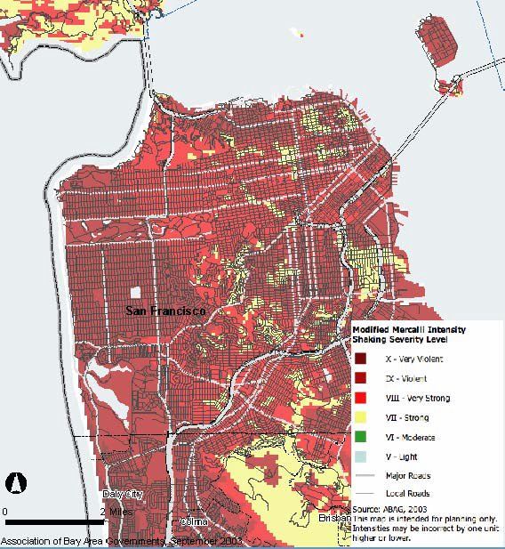
Here's a map of predicted shaking intensity in San Francisco for an event like the 1906 earthquake:

They've also got maps of liquefaction potential, and very importantly, how to make your home safer. The USGS has a publication called Putting Down Roots in Earthquake Country. It's written for people in the Bay Area, but it's got a lot of useful information for anyone living in a seismically active area. Actually, I think people in general would benefit from reading through the section on getting prepared for a disaster. A lot of the information is relevant for hazards like tornados or hurricanes.
Here's a map of predicted shaking intensity in San Francisco for an event like the 1906 earthquake:
They've also got maps of liquefaction potential, and very importantly, how to make your home safer. The USGS has a publication called Putting Down Roots in Earthquake Country. It's written for people in the Bay Area, but it's got a lot of useful information for anyone living in a seismically active area. Actually, I think people in general would benefit from reading through the section on getting prepared for a disaster. A lot of the information is relevant for hazards like tornados or hurricanes.
![]()