Monday, October 23, 2006
A couple more thoughts on the Hawaii Earthquake
I blogged about the 10/15/2006 earthquake in Hawaii last week here and here.
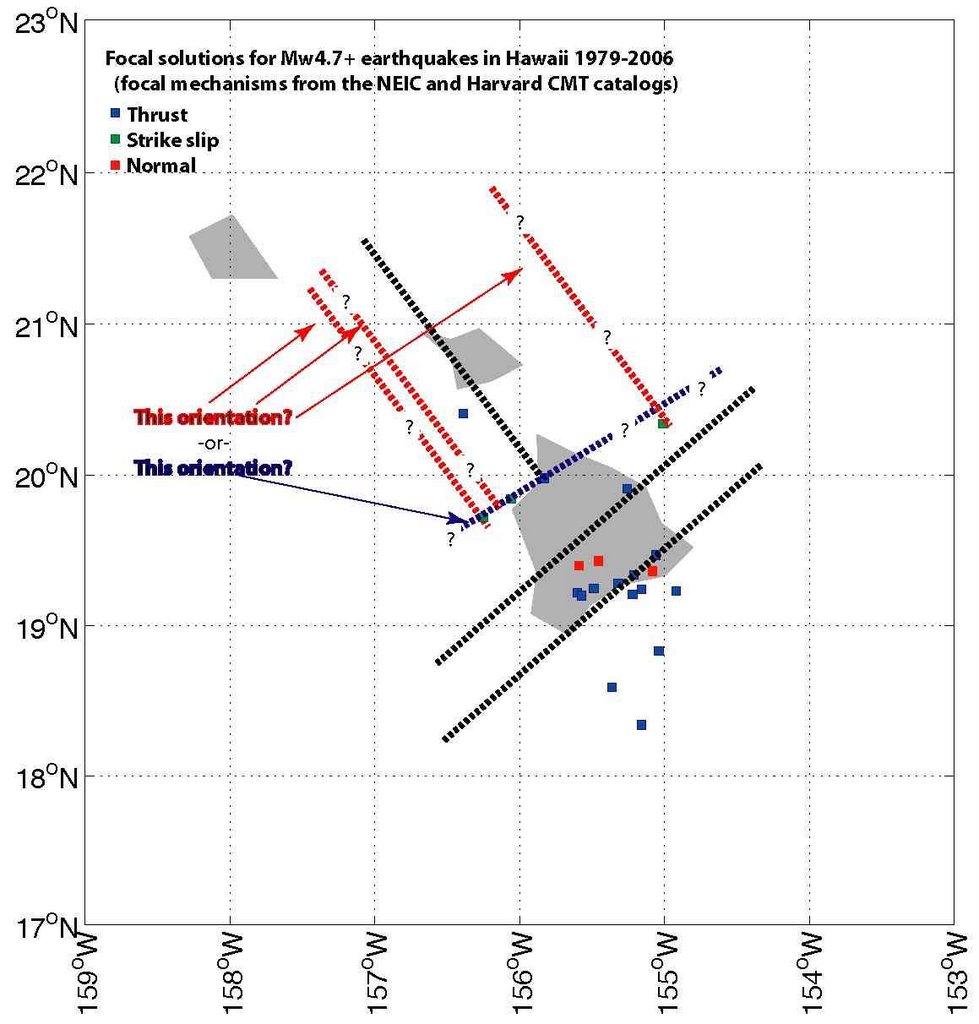
The image below shows the focal solutions for all of the earthquakes in the NEIC catalog. The focal solution for the Oct. 15 2006 event is shown in red.
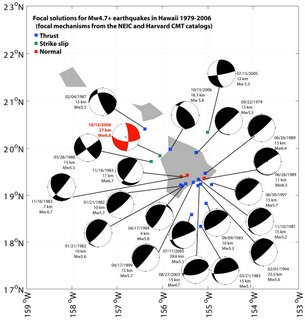
The south end of the island seems pretty straight forward. All of the faults strike NE-SW. Thrust faults occur at depth (there's a rough transition at ~10 km, but the shallowest thrust event was 4 km), and normal faults occur above that. I'm picturing something like synorogenic collapse; Hawaii is a very thick pile of material and it's about as tall as it can be, so it makes sense to me that the upper part of that pile is extending. Extension would thin the pile making it more stable (something like the detachment in the upper part of the Himalayas).
The northern part of the island where the Oct. 15 event occurred is more complex. There are two significant thrust events in that area, but they occurred on faults that strike NW-SE (EDIT: I forgot to mention that one of these thrust events was a Mw 5.8 aftershock of the Oct. 15 quake) , or in other words, at a very high angle to the thrusts at the southern part of the island. So, it seems pretty clear that the stress field that's causing the thrust faults on the northern part of the island is different from the stress field that's causing the thrusts on the southern part of the island.
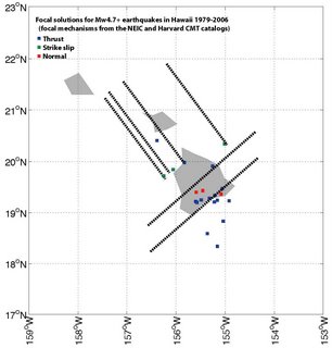
The orientation of the strike slip events in the northern part of the island isn't quite as easy to infer. There are two possibilities. The first is that the faults strike NE-SW (parallel to the faults on the southern part of the island and to the fracture zone that Chris mentioned - the blue line in the figure below). The second is that the faults strike NW-SE (as the lab lemming suggested, parallel to the thrust faults on the northern part of the island (the red lines in the figure below). I think that's more likely. If the strike slip faults strike NE-SW then there'd have to be an along-strike sense of motion (right lateral along part, left lateral along part), which seems physically unlikely. The lines in the figure below represent possible fault orientations inferred from the focal mechanisms:

I also favor a NW-SE orientation for both the strike slip and the thrust faults at the northern part of the island because something similar is observed in other parts of the world. For example, there are active thrust faults that are parallel to the San Andreas fault (a strike slip fault). In that case the two styles of faulting are caused by the oblique convergence of the Pacific and North American plates, so the SAF system isn't directly analogous to Hawaii. However it is an example of two different styles of faulting resulting from the same regional stress field.
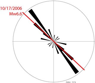
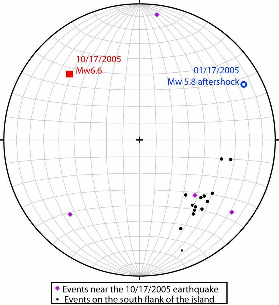
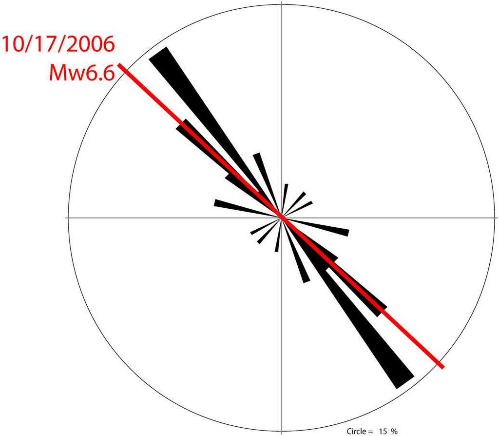
I want to speculate now about the cause of the stresses in the northern part of the island. The image below shows the orientation of the P axes from the focal mechanisms (which should be equivalent to the maximum principal stress):
The black symbols are for the southern portion of the island, and they cluster pretty tightly. There's certainly a lot more scatter in the northern portion of the island. So, the stress field in the northern part of the island is a lot more heterogeneous than in the southern part of the island.
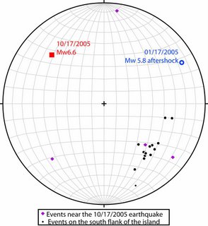
There does appear to be some overlap between the northern and the southern part of the island. The trend of the maximum principal stress for the Oct. 15 2006 quake is pretty similar to the trend of the maximum principal stress for the thrust events in the southern part of the island (shown below).
Here's a summary of my thoughts:
1) The thrust faults on the southern part of the island are resulted to the growth of the island, while the shallower normal faults are caused by extension resulting from something analagous to synorogenic collapse.
2) The stress field at the northern part of the island is much more heterogeneous than at the southern end of the island. As I discussed in an earlier message, I'd bet that the magnitude of the minimum and intermediate principal stresses at the northern end of the island are pretty similar. This means that both thrust and strike slip events would occur.
3) Both the thrust and the strike slip faults at the northern part of the island are oriented NW-SE at a high angle to the faults at the southern part of the island.
4) The northern part of the island is subjected to both local stresses related to the Hawaiian islands as well as more far field stresses associated with the movement of the Pacific plate. These far field stresses are swamped by the local stresses at the southern part of the island.
Here's my preferred interpretation of the faults on Hawaii:
The NE-SW faults are associated with local stresses while the NW-SE faults are driven by both local and far field stresses. At least that's my best guess.
The image below shows the focal solutions for all of the earthquakes in the NEIC catalog. The focal solution for the Oct. 15 2006 event is shown in red.

The south end of the island seems pretty straight forward. All of the faults strike NE-SW. Thrust faults occur at depth (there's a rough transition at ~10 km, but the shallowest thrust event was 4 km), and normal faults occur above that. I'm picturing something like synorogenic collapse; Hawaii is a very thick pile of material and it's about as tall as it can be, so it makes sense to me that the upper part of that pile is extending. Extension would thin the pile making it more stable (something like the detachment in the upper part of the Himalayas).
The northern part of the island where the Oct. 15 event occurred is more complex. There are two significant thrust events in that area, but they occurred on faults that strike NW-SE (EDIT: I forgot to mention that one of these thrust events was a Mw 5.8 aftershock of the Oct. 15 quake) , or in other words, at a very high angle to the thrusts at the southern part of the island. So, it seems pretty clear that the stress field that's causing the thrust faults on the northern part of the island is different from the stress field that's causing the thrusts on the southern part of the island.
The orientation of the strike slip events in the northern part of the island isn't quite as easy to infer. There are two possibilities. The first is that the faults strike NE-SW (parallel to the faults on the southern part of the island and to the fracture zone that Chris mentioned - the blue line in the figure below). The second is that the faults strike NW-SE (as the lab lemming suggested, parallel to the thrust faults on the northern part of the island (the red lines in the figure below). I think that's more likely. If the strike slip faults strike NE-SW then there'd have to be an along-strike sense of motion (right lateral along part, left lateral along part), which seems physically unlikely. The lines in the figure below represent possible fault orientations inferred from the focal mechanisms:
I also favor a NW-SE orientation for both the strike slip and the thrust faults at the northern part of the island because something similar is observed in other parts of the world. For example, there are active thrust faults that are parallel to the San Andreas fault (a strike slip fault). In that case the two styles of faulting are caused by the oblique convergence of the Pacific and North American plates, so the SAF system isn't directly analogous to Hawaii. However it is an example of two different styles of faulting resulting from the same regional stress field.
I want to speculate now about the cause of the stresses in the northern part of the island. The image below shows the orientation of the P axes from the focal mechanisms (which should be equivalent to the maximum principal stress):
The black symbols are for the southern portion of the island, and they cluster pretty tightly. There's certainly a lot more scatter in the northern portion of the island. So, the stress field in the northern part of the island is a lot more heterogeneous than in the southern part of the island.
There does appear to be some overlap between the northern and the southern part of the island. The trend of the maximum principal stress for the Oct. 15 2006 quake is pretty similar to the trend of the maximum principal stress for the thrust events in the southern part of the island (shown below).
Here's a summary of my thoughts:
1) The thrust faults on the southern part of the island are resulted to the growth of the island, while the shallower normal faults are caused by extension resulting from something analagous to synorogenic collapse.
2) The stress field at the northern part of the island is much more heterogeneous than at the southern end of the island. As I discussed in an earlier message, I'd bet that the magnitude of the minimum and intermediate principal stresses at the northern end of the island are pretty similar. This means that both thrust and strike slip events would occur.
3) Both the thrust and the strike slip faults at the northern part of the island are oriented NW-SE at a high angle to the faults at the southern part of the island.
4) The northern part of the island is subjected to both local stresses related to the Hawaiian islands as well as more far field stresses associated with the movement of the Pacific plate. These far field stresses are swamped by the local stresses at the southern part of the island.
Here's my preferred interpretation of the faults on Hawaii:

The NE-SW faults are associated with local stresses while the NW-SE faults are driven by both local and far field stresses. At least that's my best guess.
Comments:
<< Home
Nice post. If you're right, there's an abrupt and major change in structural style as you go from south to north - any thoughts on why that might be?

Thanks Chris. The lab lemming thought the strike slip faults might be transform faults, separating sections of the rifts on the southern end of the island that are moving at different rates. I tend to think that's not the case. If it were I'd expect there to be a lot of overlap in the direction of the maximum principal stress on the northern and southern parts of the island.
If the stress state that drives the activity on the southern part of the island is fairly localized (and it looks to me like it is), then you don't have to move very far away from that part of the island to be in a new stress state with a different structural style. I think my views are like the ones you expressed on your blog (correct me if I'm wrong). The stresses at the south end of the island are a local perturbation on a larger, regional stress field.
If that's correct I'd expect any earthquakes in the greater Hawaii area (if there were any) to have occurred on NW-SE striking faults. I'll search he NEIC catalog and see what I can find.
The southern earthquakes are coming from an active volcanic rift- kilauea has been erupting continuously for decades.
Why do you extent the faults beyond the Hawaii edifice and into/ past Maui?
Why do you extent the faults beyond the Hawaii edifice and into/ past Maui?
The faults extend to Maui because I created them by copying the blue line in the earlier figure and rotating it 90 degrees. In other words, I don't have a good reason.
Just a few thoughts from a Hawaii resident for 35+ years ...
Volcanic magma and summit inflation are measurable and give fairly predictable outcomes and explanations for eruption events in Kilauea and Mauna Loa, the southernmost active volcanoes. But this is further north (Mauna Kea) and follows activity off of Laupahoehoe, which like this quake off of Puako is well above the southern region. Hawaii is relatively stable in the middle of this huge mid-Pacific plate.
Questions come to mind in light of the huge military build-up in Hawaii, including the construction of a star wars lazer refractor platform on Mauna Kea, suspended on 'huge earthquake-proof springs' according to a sergeant in the national guard assigned to the project.
Then the possible impact from an underground Korean test and the depth of the quake ... any possible relationships???
-Kawailana
# posted by  : 12:51 AM, November 05, 2006
: 12:51 AM, November 05, 2006
Hi Kawailana,
Thanks for the comments. Are you asking if the Korean nuclear test could have triggered the Hawaiian quake? It's a cool thought but I'm doubtful since the Korean test was equivalent to an M 4.2 event, which is pretty small as far as earthquakes go.
Post a Comment
Thanks for the comments. Are you asking if the Korean nuclear test could have triggered the Hawaiian quake? It's a cool thought but I'm doubtful since the Korean test was equivalent to an M 4.2 event, which is pretty small as far as earthquakes go.
<< Home
![]()